Detail View: JCB Map Collection: Mapa sacado con la ocasion de la Entrada qui hizo â su costa â los Fertiles y dilatados Paises del Gran Chaco Gualamba, el Governor del al Prov[inci]a del Tucamàn Dn. Geronimo Matorras ...
|
Accession Number:
|
C-6509
|
|
File Name:
|
C-6509
|
|
Call number:
|
Cabinet Gk774 CeJ Ms.
|
|
Map title:
|
Mapa sacado con la ocasion de la Entrada qui hizo â su costa â los Fertiles y dilatados Paises del Gran Chaco Gualamba, el Governor del al Prov[inci]a del Tucamàn Dn. Geronimo Matorras ...
|
|
Publication date:
|
1774
|
|
Map size height:
|
52.7 cm.
|
|
Map size width:
|
37.5 cm.
|
|
Item description:
|
manuscript
|
|
Geographical description:
|
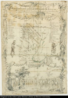
Map of the interior of Argentina, Paraguay, and Bolivia. Cartographic elements include lines of latitude and longitude and path of the main route from Buenos Aires to Potosí (at the very top of the map). Decorative elements include native Americans meeting with Spanish soldiers, bird, horses, and military encampment. Items in the image are numbered and lettered for identification in a key above.
|
|
References:
|
http://www.ecomchaco.com.ar/cultura/chaco/tema011.htm (Feb. 2003)
|
|
Geographic Area:
|
South America
|
|
Historical notes:
|
This map was given as a presentation map and provided a record of the expedition of Geronimo Matorras, Governor of Tucumán, into the interior Indian country, or Gran Chaco Gualamba. The drawing memorializes the governor's meeting with "El famoso Indio Paykin." Another copy of this map is held by the Archivo General de Indias, Seville.
|
|
Normalized date:
|
1774
|
|
Creator:
|
Julio Ramón de César
|