Detail View: JCB Map Collection: Baye et Ville de la Havana ou de S. Christoval
|
Accession Number:
|
34241
|
|
File Name:
|
34241-1
|
|
Call number:
|
B738 C797r
|
|
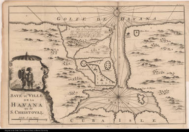
Map title:
|
Baye et Ville de la Havana ou de S. Christoval
|
|
Place of Publication:
|
[Amsterdam]
|
|
Publisher:
|
[J. Frederic Bernard]
|
|
Publication date:
|
[1738]
|
|
Map size height:
|
20.9 cm.
|
|
Map size width:
|
30.9 cm.
|
|
Item description:
|
fold-out engraved map; vol. 1, following p. 8
|
|
Geographical description:
|
Map of Havana, Cuba, and surrounding area. Cartographic elements include scale, topographical details, shoals, compass rose, locations of rivers, churches, and forts. In the cartouche are two native Americans with feathered headdresses, shield, spear, and bucket or basket.
|
|
Source author:
|
Coreal, Francisco, 1648?-1708
|
|
Source title:
|
[Voyages de François Coreal aux Indes Occidentales] Recueil de voyages dans l'Amerique Meridionale, contenant diverses observations remarquables touchant le Perou, la Guiane, le Bresil, &c. traduits de l'espagnol & de l'anglois. Tome premier.
|
|
Source place:
|
A Amsterdam : Chez J. Frederic Bernard, MDCCXXXVIII
|
|
Geographic Area:
|
Caribbean
|
|
Historical notes:
|
Havana was formerly known as Villa de San Cristóbal de La Habana. Efforts to protect it from pirates and the English led to its being one of the most heavily fortified cities in the new world.No Spanish original of Coreal's voyages is known, and the identity of the author is frequently questioned. Coreal may be a pseudonym for the real traveler who visited the West Indies, Florida, Mexico, Brazil, Uruguay, and Peru.
|
|
Normalized date:
|
1738
|