Detail View: JCB Map Collection: Americae sive Novi orbis, nova descriptio.
|
Accession Number:
|
6009
|
|
File Name:
|
6009-1
|
|
Call number:
|
Z 077 1598 1 / 3-SIZE (copy 2)
|
|
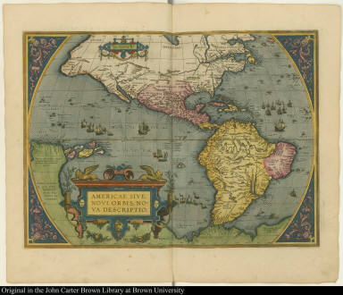
Map title:
|
Americae sive Novi orbis, nova descriptio.
|
|
Place of Publication:
|
[Antwerp]
|
|
Publisher:
|
[Plantin Press]
|
|
Publication date:
|
1587
|
|
Map size height:
|
35.4 cm.
|
|
Map size width:
|
48.4 cm.
|
|
Item description:
|
engraved map, hand coloring; following p. 5
|
|
Geographical description:
|
Map of North and South America. Cartographic elements include lines of latitude and longitude, locations of rivers and some settlements. Decorative elements include ships, boats, and sea monsters.
|
|
Source author:
|
Ortelius, Abraham, 1527-1598
|
|
Source title:
|
[Theatrum orbis terrarum. French] Theatre de l'univers, contenant les cartes de tout le monde
|
|
Source place:
|
A Anvers : de l'Imprimerie Plantienne, pour Abraham Ortel autheur mesme de ce liure., M. D. XCVIII
|
|
References:
|
Broecke, M.P.R. van den Ortelius Atlas Maps, No. 11; cf. Burden P.D. Mapping of North America, 64; Koeman, C. Atlantes neerlandici, Ort. 36; Skelton, R.A. Bib. note, in Facsimile ed. of Ortelius, A. Theatrum orbis terrarum, p. ix, [xi]
|
|
Geographic Area:
|
Western hemisphere
|
|
Historical notes:
|
Ortelius was the creator of the first true atlas (defined as a collection of uniform map sheets and sustaining text bound to form a book for which copper printing plates were specifically engraved). Frequently revised, this particular atlas was the last one to be printed during Ortelius's lifetime and was derived from Gerard Mercator's world map of 1569.
|
|
Normalized date:
|
1587
|
|
Creator:
|
Abraham Ortelius
|