Detail View: JCB Map Collection: Connecticut and Parts adjacent.
|
Accession Number:
|
M1600
|
|
File Name:
|
M1600-2
|
|
Call number:
|
Cabinet Cb777 RoB780
|
|
Map title:
|
Connecticut and Parts adjacent.
|
|
Place of Publication:
|
Amsterdam
|
|
Publisher:
|
bÿ Covens and Mortier and Cóvens junior
|
|
Publication date:
|
1780
|
|
Map size height:
|
52.3 cm.
|
|
Map size width:
|
59.6 cm.
|
|
Item description:
|
engraving, hand coloring
|
|
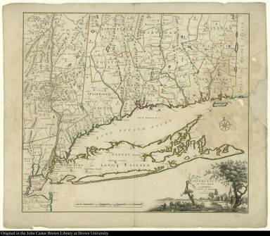
Geographical description:
|
Map of Long Island, New York, and Connecticut. Cartographic elements include scale, routes of roads, location of rivers, and some topographical details. Decorative cartouche shows bucolic scene of a town with church, cattle or domestic animals, and dwellings.
|
|
References:
|
Thompson, E. Maps of Connecticut before 1800, p. 42; Phillips, P.L. Notes on ... Bernard Romans, p. 86-88
|
|
Geographic Area:
|
North America
|
|
Historical notes:
|
Bernard Romans was a British surveyor who was active surveying the New York area, as well as the Florida area. He joined the colonial forces during the American Revolution. Later he planned fortifications on the Hudson River, and made maps of the region around the Hudson Highlands.Romans' map of Connecticut was originally published in Hartford in 1777. This Dutch edition includes revisions in the depiction of Long Island, probably added from Romans' personal knowledge.
|
|
Normalized date:
|
1780
|
|
Creator:
|
Bernard Romans
|
|
Creator:
|
Hendrick Kloekhoff
|