COLLECTION NAME:
JCB Map Collection
Record
Accession Number:
01644
File Name:
01644-013
Call number:
B598 A185g /1-SIZE
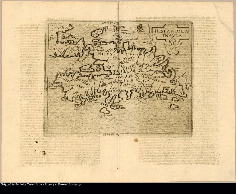
Map title:
Hispaniola insula
Place of Publication:
Cologne
Publisher:
Bey Johann Christoffel, auff S. Marcellenstrass.
Publication date:
M.D.XCVJJJ.
Map size height:
28 cm
Map size width:
38 cm.
Item description:
Engraved map, following leaf 12 [second count]
Geographical description:
Map of the islands of Hispaniola, present-day Haiti and the Dominican Republic, and part of Cuba.
Source author:
Acosta, José de, 1540-1600
Source title:
Geographische vnd historische Beschreibung der uberauss grosser Landtschafft America: welche auch West Jndia, vnd jhrer grösse halben die New Welt genennet wirt. Gar artig, vnd nach der Kunst in XX. Mappen oder Landtaffeln verfasset, vnd jetzt newlich in Kupffer gestochen, vnd an tag gegeben. Dabey auff dem Rücken ieder Mappen gefunden wirdt, die Gestalt, Art, vne vornembste Gelgenheit der Landtschafft ... Zu mehrem Verstand vnd Erklärung gemelter Landschafft America, ist hiebey gefügt ein schön vnd nützlicher Tractat von der Natur, Art, vnd Eygenschafft der Newer Welt ... Erstlich durch einen hochgelehrten vnd dess Landes wolerfahrnen Mann, in lateinischer Spraach gar herrlich beschrieben; nun aber durch ein Liebhaber der Historien vnd Land beschreibungen dem gemeinen teutschen Mann zu gutem, gar trewlich vbergesetzt, vnd ins teutsch bracht
Source place:
Gedrückt zu Cölln: Bey Johann Christoffel, auff S. Marcellenstrass., Jm Jahr M.D.XCVJJJ.
Cartobibliographic notes:
Translation of: De natura Novi Orbis libri duo. The maps are attributed to Johannes Matalius Metellus and are derived from Cornelis Wytfliet's atlas. This is the second printed map to use Canada in its title.
Geographic Area:
Caribbean
Normalized date:
1598
LC bibliographic number:
b22205706
Hispaniola insula