COLLECTION NAME:
JCB Map Collection
Record
Accession Number:
36187
File Name:
36187-19
Call number:
Cabinet OVERSIZE Cartographie du Canada
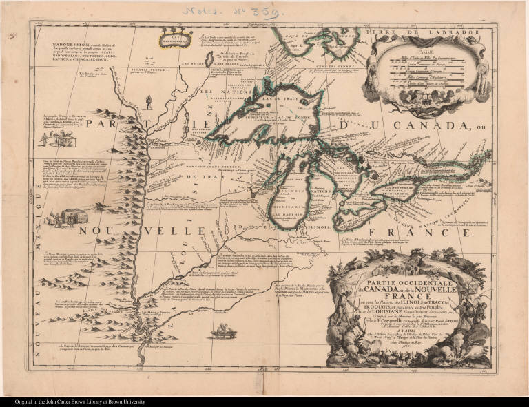
Map title:
Partie occidentale du Canada ou de la Nouvelle France ou sont les Nations des Ilinois, de Tracy, les Iroquois, et plusieurs autres Peuples ...
Place of Publication:
Paris
Publisher:
Chez J. B. Nolin [Jean Baptiste Nolin] ...
Publication date:
1688
Map size height:
44.4 cm.
Map size width:
59.5 cm.
Item description:
engraving, hand coloring
Geographical description:
Map of New France, including the Great Lakes and the area around the Mississippi River. Cartographic elements include lines of latitude and longitude, scales, some topographical details, location of rivers (especially the Mississippi River), lakes, forts, and settlements of native Americans. Decorative elements include scenes from Theodor de Bry's America, part 1 (cooking fish over a fire and building boats). Also includes a scene of a man being executed with a war club before a dwelling and man being roasted over a fire (scene of cannibalism). Decorative cartouche includes native Americans hunting buffalo [?] with bows and arrows. Also includes a waterfall, beaver [?], European men with guns or muskets, and coat of arms.
Cartobibliographic notes:
This map is a collaboration between Coronelli, Tillemon, and Nolin. It is one of the best representations of the period of the Great Lakes, particularly Lake Superior. Sources for the information shown on the map include Marquette, Joliet, and La Salle. Jean Baptiste-Louis Franquelin, who was based in Quebec and received much of the information brought by the French explorers, was also a significant source of information for this map.This map was number 19 in a made-up atlas, Cartographie du Canada, assembled by Henry Harrisse and later bought by Samuel Latham Brown. It was disbound when purchased and is held separately by the Library.
References:
Burden, P.D. Mapping of North America, II, 630; Kaufman, K. The Mapping of the Great Lakes in the Seventeenth Century, no. 12; www.pequotmuseum.org/uploaded_images/CC2DB15E-FC71-4988-BC3D-4481CE33CA70/CartoIInew.pdf (Oct. 2007)
Geographic Area:
North America
Normalized date:
1688
Creator:
Vincenzo Coronelli
Creator:
Jean Nicolas du Tralage, sieur de Tillemon
Partie occidentale du Canada ou de la Nouvelle France ou sont les Nations des Ilinois, de ...