COLLECTION NAME:
JCB Map Collection
Record
Accession Number:
36187
File Name:
36187-18
Call number:
Cabinet OVERSIZE Cartographie du Canada
Map title:
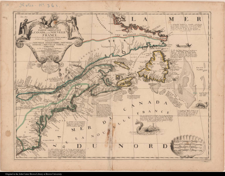
Partie orientale du Canada ou de la Nouvelle France ...
Place of Publication:
Paris
Publisher:
Chez I. B. Nolin [Jean Baptiste Nolin] ...
Publication date:
1689
Map size height:
44.5 cm.
Map size width:
59 cm.
Item description:
engraving, hand coloring
Geographical description:
Map of New France, including part of northeastern Canada and New England, from Labrador south to present-day South Carolina. Cartographic elements include lines of latitude and longitude, scales, sea banks or shoals, location of rivers (especially the Saint Lawrence River), lakes (especially Lake Ontario), forts, and settlements of native Americans (especially the Five Iroquois Nations). Decorative elements include fish [cod] or sea monsters and native Americans in a canoe. Decorative cartouche includes native Americans, one armed with a gun or musket wearing wooden [?] armor, the other shooting at bear and deer or stag with a bow and arrow. Also includes a coat of arms.
Cartobibliographic notes:
This map is a collaboration between Coronelli, Tillemon, and Nolin. It is the earliest French map of the English colonies in North America and includes brief historical notes describing Dutch, English, and French explorations and claims to parts of the area. This map was number 18 in a made-up atlas, Cartographie du Canada, assembled by Henry Harrisse and later bought by Samuel Latham Brown. It was disbound when purchased and is held separately by the Library.
References:
Burden, P.D. Mapping of North America, II, 657; McCorkle, B.B. New England in Early Printed Maps, 689.2; www.pequotmuseum.org/uploaded_images/CC2DB15E-FC71-4988-BC3D-4481CE33CA70/CartoIInew.pdf (Oct. 2007)
Geographic Area:
North America
Normalized date:
1689
Creator:
Vincenzo Coronelli
Creator:
Jean Nicolas du Tralage, sieur de Tillemon
Partie orientale du Canada ou de la Nouvelle France ...
