COLLECTION NAME:
JCB Map Collection
Record
Accession Number:
10796
File Name:
10796-1
Call number:
Z Z1 /1 /3-SIZE
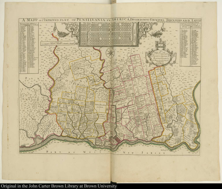
Map title:
A Mapp of ye Improved part of Pensilvania in America, Divided into Countyes, Townships and Lotts
Place of Publication:
[London]
Publisher:
Sold by P. Lea at ye Atlas and Hercules in Cheapside
Publication date:
[1687]
Map size height:
40 cm.
Map size width:
53.8 cm.
Item description:
engraving, hand coloring
Geographical description:
Map of part of Bucks, Chester, and Philadelphia counties in Pennsylvania showing land ownership. Inset of plan of Philadelphia. Cartographic elements include scale and location of land holdings, counties, and townships. Decorative cartouche contains dedication to William Penn with the Penn family coat of arms. Also includes net full of fish and farm implements such as sickle, fork, and spade.
Cartobibliographic notes:
Known in three editions, the version here with only Philip Lea's name as publisher is the first.This map is no. [108] in an atlas with binder's title, Atlas 2.
References:
Phelps Stokes, I.N. American Historical Prints, B-44; Schwartz, S.I. Mapping of America, Plate 70
Geographic Area:
North America
Historical notes:
This map records in remarkable detail the original elements of William Penn's royal grant and is the earliest detailed survey of an English colony in America. Captain Thomas Holme, Penn's surveyor-general, produced the first printed plan of a city in the present-day United States in 1683. A seven-sheet version of Holme's map was made circa 1687 and this smaller scale map was probably reduced from that map at about the same time.
Normalized date:
1687
Creator:
Thomas Holme
Creator:
John Harris
A Mapp of ye Improved part of Pensilvania in America, Divided into Countyes, Townships and...